OASIS Implementation: Practical Use of EO data and AI solutions in Lithuania
The implementation of the OASIS project (Optimizing Access to Services through Integrated EO and AI Solutions for Innovative Societies) marks an important step towards more modern, accurate and farmer-friendly agricultural support in the Latvia–Lithuania cross-border region.
The OASIS project is being implemented under the Interreg VI-A Latvia–Lithuania Programme 2021–2027 with its main purpose to improve the use of geospatial data in agricultural administration. OASIS brings together two accredited paying agencies: the National Paying Agency under the Ministry of Agriculture of Lithuania, acting as the lead partner, and the Rural Support Service of Latvia as the project partner.
The implementation of the OASIS project is moving from strategic planning to practical testing with local stakeholders. As part of the Interreg Latvia–Lithuania cooperation, the project aims to improve the use of EO (Earth Observation), AI (artificial intelligence) and geospatial data in public services related to agriculture, land monitoring and support administration. A key part of this implementation is cooperation with agricultural specialists of the municipalities, who work directly with declared areas, field boundaries and land-use changes.
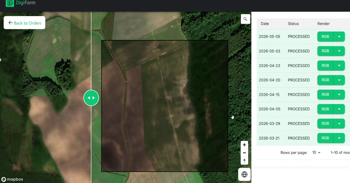
In spring 2026, practical workshops were organised with the Agriculture Divisions of Klaipėda District Municipality and Kupiškis District Municipality in Lithuania. These meetings demonstrated how the service supplier Digifarm platform can support the assessment of real field situations by using specific satellite imagery.
The workshops were not only theoretical presentations, but also practical sessions where specific cases from the municipalities were reviewed and discussed together with local specialists. In the workshops, RGB images helped participants visually identify changes such as drainage works, demolition areas, park development and field boundary situations, while NDVI imagery showed the condition and intensity of vegetation, which is useful for analysing crop growth, mowing, excess moisture, irrigation-related issues and changes in vegetation over time.
During the workshop with Klaipėda District Municipality Agricultural Division, four practical cases were analysed. These included an irrigation-related cereal field, mowing monitoring, drainage system installation, and park development or territorial change monitoring. By comparing satellite images from different dates, participants assessed how vegetation condition, land cover and farming activities can be identified in the platform. NDVI imagery was especially useful for evaluating vegetation intensity and changes over time, while RGB imagery helped participants visually compare field and territorial changes.
The Klaipėda cases also showed the importance of using images from several different dates. Due to higher cloud cover in the coastal region, some satellite images may be less clear or less informative. For this reason, multi-date comparison is essential for more reliable interpretation. The workshop demonstrated that service supplier Digifarm can help identify changes that may not be immediately visible from a single image, especially when monitoring mowing, drainage works or gradual territorial development.
The workshop with Kupiškis District Municipality Agriculture Department focused mainly on the verification of declared agricultural activities and land-use changes. Participants reviewed cases where applicants had declared vegetable garden areas and assessed whether the gardens were correctly indicated and whether field boundaries had been properly drawn. This is highly relevant for agricultural support administration, where accurate field declaration is necessary for fair and correct decision-making. In addition, the Kupiškis workshop included an irrigation-related field case, where areas affected by excess moisture were reviewed using RGB and NDVI imagery. Another analysed case was related to the demolition of old buildings and construction-related land-use change.
These examples showed how satellite imagery can support the monitoring of not only agricultural activity, but also broader changes in rural territories.
Overall, the workshops confirmed that the Digifarm platform can be a useful tool for municipal agriculture departments. It can support the assessment of declared areas, identification of land-use changes, monitoring of vegetation condition and verification of specific field situations. The use of NDVI imagery helps specialists better understand vegetation patterns, while RGB images provide a clear visual basis for comparison.
The practical implementation activities under OASIS are important because they connect digital innovation with real administrative needs. By testing the platform together with municipal specialists, the project ensures that the developed solutions are relevant, understandable and applicable in daily work. These activities also strengthen cooperation between national and local institutions and support the broader goal of making agricultural monitoring more efficient, transparent and evidence-based.
Through these practical workshops, OASIS demonstrates how tools based on EO data and AI can contribute to smarter public services. The project helps create better conditions for more efficient agricultural support administration, upgrade land monitoring and evidence-based decision-making in Lithuania and the Latvia–Lithuania cross-border region.
For more information, please visit the OASIS website: Optimizing Access to Services through Integrated EO and AI Solutions for Innovative Societies – Latvia-Lithuania Programme
This message has been prepared with the financial support of the European Union. The National Paying Agency is responsible for its content, which does not necessarily reflect the opinion of the European Union.

Last updated: 18-06-2026
Related news:
Horizon Europe Sister Projects Discuss Data-Driven Tools for Sustainable Agriculture
NPA, Lithuania, showcases Its AI achievements at Panta Rhei Conference in Dublin
Mid-Term AgriDataValue Review: Reflecting on Three Years of Progress and Looking Ahead
Strengthening Agricultural Monitoring through Innovation and Cooperation: JRC FIRE Workshop